
№ 003521 SEPTEMBER 2026PLACENAZCA PAMPA, ICA REGION, PERU
The Nazca Lines
The Woman Who Swept the Desert for Fifty Years
Unsolved since 1927Maria Reiche spent fifty years on a Peruvian desert with a household broom, sweeping dust off lines that had been scratched there two thousand years earlier. She measured as she swept. Her explanation for why the Nasca made them is the one the evidence has treated worst.
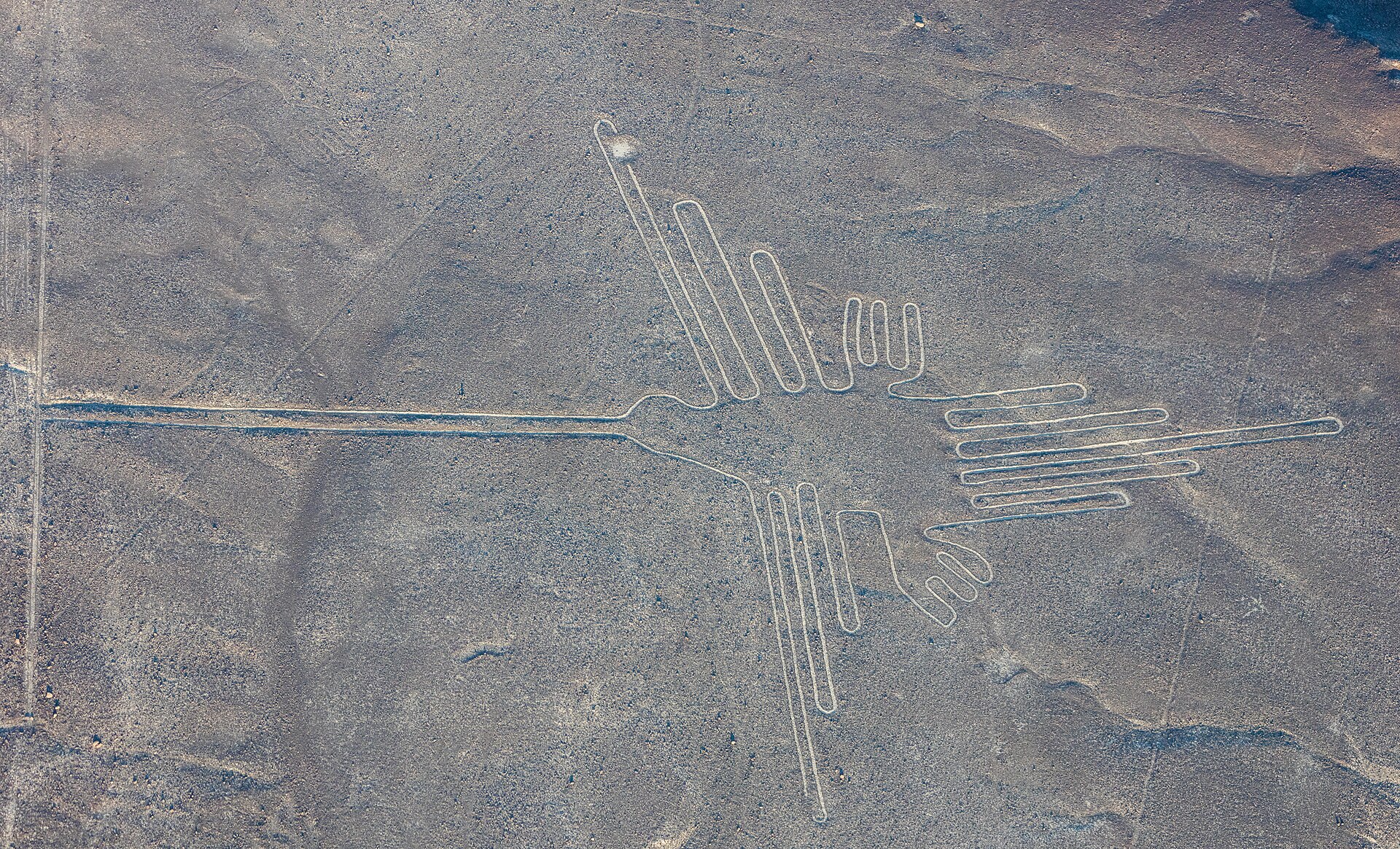
What We Know
On the evening of 22 June 1941, an American historian named Paul Kosok stood on a flat stretch of Peruvian desert and watched the sun set along the bearing of a line cut into the ground at his feet. He called the plain the largest astronomy book in the world. The person who took that idea off his hands was Maria Reiche, a Dresden-born mathematician who had come to Peru in 1932 to tutor children and was translating his papers for him. When he left in 1948 she inherited the work, and did not put it down again.
The ground she inherited had barely been looked at. In the mid-1920s the Peruvian archaeologist Toribio Mejía Xesspe walked the foothills above the plain, saw the marks below, and filed them as ancient aqueducts and roads. What is down there is a floor of dark, iron-stained stones lying on paler ground. Drag the stones aside, heap them along the edge, and you get a pale stripe with a dark border. Under an inch of rain falls in a year. The stripe stays.
The Nasca and the people before them made a great many: over 800 straight lines, some 300 geometric figures, and animal and plant designs from fifty feet to twelve hundred. Potsherds on and beside the marks show people using the pampa from at least the first century BCE into the fifteenth century CE.
Reiche measured. She also cleaned, first with a rake and then with brooms, going through enough to become known locally as the woman who swept the desert. She balanced on ladders for a raised view, worked from Peruvian air force photographs after 1947, fought an irrigation scheme in 1955, and paid watchmen out of her own money. She died in 1998, four years after the pampa was inscribed as a World Heritage site, still holding that the lines were an astronomical calendar.
Hers was the first explanation anyone put to a statistical test. It is also the first that lost.
The Roadblock
The phrase “the Nazca Lines” makes a single object out of something that isn’t one. It is fifteen hundred years of use, in at least two construction styles, spread across a plain so wide the most recent survey had to screen 629 square kilometres, made by people who left no writing. Asking what the lines are for is close to asking what a city is for.
Dating makes it worse. A potsherd lying on a geoglyph dates the afternoon somebody stood there, not the season somebody cut it: the record is talkative about use and nearly silent about construction. The relief figures on the hillsides are believed older than the giant outlined animals, which are believed older than parts of the straight-line network, and “believed” is carrying most of the weight in that sentence.
Then there is the perverse shape of the evidence: the hypotheses that can be tested cleanly are the ones that have failed. Line bearings are measurable, so astronomy got the first statistical test and failed it. Groundwater can be mapped, and the mapping came back weak. What is left upright is the set of readings hardest to falsify, which is not the same as the set most likely to be true.
Best Guesses
A calendar written in sightlines
Kosok’s solstice sunset was real, and Reiche spent five decades adding to it: azimuths, horizon-rising alignments, figures she read as constellations, Western ones as it turned out, unattested in Andean ethnohistory. The practice existed on this coast: in the Chincha Valley, 2,300-year-old paired line segments mark the June solstice sunset. Then somebody counted. Gerald Hawkins ran 186 Nazca lines against a computed sky and found about a fifth pointed at something celestial, roughly what 186 random lines would give you. Anthony Aveni’s later survey found the same, and turned him toward water.
A petition for water
The sharpest version broke on its own data. David Johnson argued that trapezoids lie over water-bearing faults; his own project ran the statistics and the correlation came back not significant. Katharina Schreiber’s objection is plainer: of the thirty-nine puquios she has studied, the spiral galleries the Nasca cut to reach groundwater, six draw on the valley-side sources the argument needs. The softer reading is harder to shift. Johan Reinhard took the whole complex for a water and fertility cult on one of the driest inhabited coastlines on earth: marine shells at the trapezoids, animal figures as fertility symbols. Aveni and Gary Urton mapped at least 62 ray centres feeding some 800 straight lines, virtually every one on high ground where water leaves the mountains for a valley.
Pathways walked to Cahuachi
Cahuachi is a huge adobe mound complex on the Nazca River almost nobody lived in. Helaine Silverman argued in 1994 that this made it a pilgrimage destination, not a city: no permanent settlement, but mound fills packed with the refuse of heavy, episodic use. The network agrees. The formal grid has around ten narrow entrances on the Ingenio side and two wide ones on the Nazca side, one facing Cahuachi across the river. In 1984 Clive Ruggles stumbled into a 4.4-kilometre figure whose form, he wrote, only became evident as he walked it end to end. His own co-author supplies the objection: the contours are too well preserved, Nicholas Saunders argues, for crowds and their animals to have walked them repeatedly.
Two traditions, two audiences
The newest reading says the question has the wrong grain. In 2024 Masato Sakai’s team turned a machine-learning model loose on aerial imagery of the pampa, then walked to whatever it flagged: 303 new figures confirmed on foot in six months. The two styles pull apart. The small relief figures average 9 metres, and sit a mean 43 metres from informal trails; 81.6 per cent depict humans or what humans altered: humanoids, severed heads, llamas. The giant outlined ones average 90 metres, sit beside the formal network, and are 64 per cent wild animals, with no humanoids. The split covers 733 figurative marks, not the thousands of lines and trapezoids around them, and the paper says it has not closed the question.
The Verdict
Sakai’s 2022–23 season left 968 promising candidates unvisited. Later seasons added 248 more, announced in July 2025; 160 were figurative, pushing that catalogue to 893 and settling nothing. That backlog is the closest thing here to a scheduled experiment. If the small relief figures keep coming back human and trail-adjacent while the giant animals stay wild and network-adjacent, the two-traditions split gets hard to argue with. If the pattern breaks, it dies.
The better test is the expensive one nobody funds: dig under the trapezoids and find out what was left there, and when. Whether that stays possible is a political question. In May 2025 Peru’s culture ministry cut the protected reserve by 42 per cent and opened the ground to mining permits, then reversed itself inside a fortnight.
Reiche kept the pampa intact for fifty years so somebody could eventually check her. The survey permit runs through 2026.
Where do you stand?
That’s one. There’s another every morning at 6 a.m. local time.
Share where you stand
What Didn't Hold Up
Details that circulate with this case but failed verification against independent sources. Cut from the story above — listed so you know they weren't missed.
“The Nazca figures can only be seen from the air, which is why nobody knew they were there until aircraft flew over the pampa.”
The 2024 PNAS survey found every individually sited figurative geoglyph it checked was visible from ground trails, and the small relief figures sit on hill slopes to be seen from a distance. A 2007 study of ~1,500 Palpa geoglyphs found each visible from the ground. Mejía Xesspe found them on foot in the 1920s.
“AI has solved the Nazca Lines: a machine-learning survey worked out what the geoglyphs were for.”
The headlines describe Sakai et al. 2024, whose closing sentence declines to close the question: it does not preclude the geoglyphs having functioned at another level. Its result is a difference in purpose between two styles of figurative geoglyph, 733 marks — not the pampa's thousands of lines and trapezoids.
“The Nasca flew hot-air balloons, which is how they saw their own drawings from above.”
The flight is real but modern: Jim Woodman and Julian Nott flew Condor I over the pampa on 28 November 1975 using period-available materials. No Nasca balloon, or any Nasca depiction of one, has been excavated. Woodman's own book calls the flight a demonstration of an ancient possibility, nothing more.
The Rabbit Hole
- PNAS: AI-accelerated Nazca survey nearly doubles the number of known figurative geoglyphsthe 2024 paper in full, open access, with drone photographs of fifteen of the new figures
- Clive Ruggles: Desert labyrinththe archaeologist who found a 4.4-kilometre figure in 1984 by walking into it, and waited twenty years to go back
- The Nasca Lines Project (1996–2000)the water-and-faults project's own report, including the statistics that didn't support it
- Discover: The Nasca Lines Solutionthe water argument at full length in 2000, with Aveni, Reinhard and the objections all in one room
- Institute of Nasca, Yamagata Universitythe survey programme's own site, where new confirmed figures appear first